Table Mountain Water Source Area maps
Base Layer
- Title
- "Quick view" dashboard
- Description
This dashboard has been developed to inform residents, students and other interested users about the status of groundwater in Cape Town. The dashboard is part of a bigger project by the Table Mountain Water Source Partnership and its planning and development was funded by ABInBev and the Danish Embassy through WWF South Africa. If you need help you can visit the How to navigate page.
Background
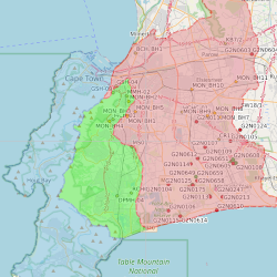
South Africa’s water source areas produce disproportionately greater volumes of water in relation to their size. Only 10% of our land provides us with 50% of our surface run-off (water in wetlands, streams and rivers). One of these strategic water source areas is the Table Mountain Water Source Area (TMWSA) in the City of Cape Town Metropolitan Municipality. This is an easily understandable dashboard to present groundwater information of the TMWSA on a map, which is derived from an up-to-date groundwater database set up and maintained from various sources of data.
For more information on the South African water source areas visit this webpage.
- Organization
- Table Mountain Water Source Partnership
- Person
- Klaudia Schachtschneider (WWF South Africa)
- KSchacht (at) wwf.org.za
- Phone
- +27 21 657 6600
- Website
- https://tablemountain.groundwaterinfo.africa/index.php/view/media/getMedia?repository=tmwsa&project=1_water_source_areas&path=media/help/index.html
- Projection
- EPSG:3857
- Extent
- 2021606.25594712560996413, -4059124.83069858280941844, 2082969.15814576949924231, -4009131.40183766419067979
- Web Map Service
- WMS Url
- WMTS Url